The strike zone
Besides changing the federal government's flood maps, recent events have shifted how scientists predict hurricanes.
In their new research, they are focusing on storm data from the last 50 years and discounting older, more questionable data, said Joe Suhayda, a retired Louisiana State University professor who specializes in storm surge modeling. That, in effect, increases the predicted severity of 100-year storms, simply because the impact of powerful storms in recent years isn't diluted by decades of substandard data from the first half of the 20th century.
Hundred-year flooding can be caused by a moderate storm, such as 1995's Opal, hitting in just the right spot, but it also can be caused by the wide swath of a major storm, such as Katrina, that strikes 70 miles away.
Scientists also are rethinking how much emphasis they put on historical flooding, Suhayda said. The standard practice has been to take the recorded storms in an area and use them in a computer model that simulates thousands of years.
But that focuses too narrowly on the place of a hurricane's landfall, ignoring neighboring areas that face the same dangers, Suhayda said. Wise coastal planning is based on risk, not merely the circumstance of one storm or another.
This is the problem with FEMA maps, according to some people involved in flood plain management. Hundred-year flooding can be caused by a moderate storm, such as 1995's Opal, hitting in just the right spot, but it also can be caused by the wide swath of a major storm, such as Katrina, that strikes 70 miles away.
If the damage spreads well beyond landfall, "why should (the 100-year storm) be based on the fact that that storm hit there?" asked John Eringman, a retired flood plain coordinator for the U.S. Army Corps of Engineers.
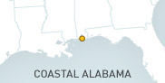
Current research indicates that the area between Grand Isle, La., and the Alabama-Florida line is at the highest risk on the Gulf Coast for Category 3, 4 and 5 hurricanes, Suhayda said. New Orleans has the highest probability.
Certainly the Jarretts know what it's like to be in the strike zone.
That year of flooding on Fowl River caught up with them. The county wouldn't let them put any more money into their property unless they elevated the remaining structure or demolished it and built a new, higher house.
"The slab and everything went to the dump," Sandy Jarrett said.
Because they had flood insurance—living in the flood plain in a mortgaged house, they had to—the National Flood Insurance Program paid $30,000 of the cost of building higher.
The new home had to be at least 9 feet above sea level. They built it to about 15 feet, as high as houses on the shore of Mobile Bay.
"We didn't want any water," Sandy Jarrett said. "If we get water now, the whole of Mobile will be wiped out."
(Press-Register Staff Reporter Dan Murtaugh contributed to this report.)
Originally published on June 9, 2007 in the Mobile Press-Register. Courtesy of the Press-Register 2007 © All rights reserved. Reprinted with permission.